Saturday, June 25, 2016

David versus Goliath - Fairey Swordfish against the Bismarck 1941 - An Addendum

In the original article this author indicated that at the time he had been unable to find detailed particulars regarding KMS Bismarck’s weapons, i.e. gunnery, fire control system. As a substitute land-based analog gunnery “predictors”, both German and British, as well as the US Navy’s Mk IA Fire Control Computer were shown. For the reader's convenience, and as cross-reference that site is; http://arnhemjim.blogspot.com/2013/10/david-versus-goliath-fairey-swordfish.html

Apologies are in order, as the information was right at hand in a resource which was even cited in the original document. Interested and sharp readers may well have discovered the data if they explored the referenced source material in any depth. Look under Internal View in; http://www.bismarck-class.dk/bismarck/bismarck_menu.html .

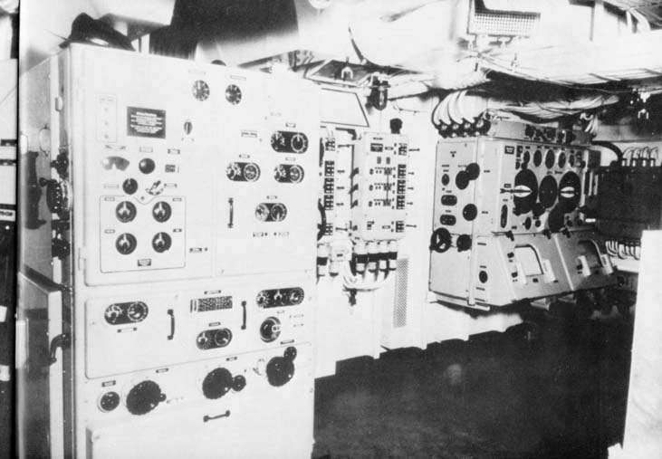
With full acknowledgment and expressed gratitude to that site the following are a series of photographs taken in Bismarck’s Command and Calculation Headquarter (sic) (Radar Navigation and Evaluation Room), and of a calculator, i.e. analog computer, in the Fire Control Room.


In addition I’ve subsequently been able to find an excellent Internet site which discusses Naval Gunnery in the Royal Navy during World War II, in some detail, specifically including the system installed in HMS Hood. For those who may be interested see;
http://www.godfreydykes.info/royal%20naval%20gunnery%20in%20WW2.htm . From another web site here is a photograph of a typical WWII Royal Navy fire control computer in a heavy combatant (battleship, battle cruiser, heavy cruiser, exact ship unknown) of that era, erroneously labelled a "transmitting station" possibly for security reasons? It suffices that HMS Hood's fire control computer was not nearly this modern.


In order to give the reader just a brief perspective on how far the weapon systems technology has evolved from the analog gear teeth and vacuum tubes of those days, I thought a brief look at what is available as unclassified information on the US Navy Mk-99 Fire Control System (FCS) might prove interesting. The Mk-99 FCS is one of the principal digital “brain lobes”, and as such the major surface-to-air missile component of the AEGIS Combat System. Integrated with other digital weapon control systems, it provides for a simultaneous mufti-warfare/multiple target engagement capability. It has evolved into a distributed, open architecture system, capable of expansion to accommodate emerging technology as well as future emerging threat packages.

Following are block diagram charts depicting the AEGIS Weapon System, Mk-99 FCS, and photographs of a portion of the wide screen displays and control panels comprising the modern Combat Information Center of three Aegis Class cruisers. The imagery is of early system displays and controls, circa 1997-1998, in the USS Vincennes (CG-49), USS Normandy (CG-60), and USS John S. McCain (DDG-56). Newer configurations are obviously classified.


Friday, June 10, 2016

Newly Discovered Paintings of the Battle of Waterloo

There has been a recently discovered set of watercolours, attributed to a Thomas Stoney, an Irish tourist, who visited the battlefields at Waterloo, La Havre Sainte and Quatre Bras on 20 June 1815, only two days after the battle. The paintings are believed to have been done on either 20 or 21 June 1815. The set of 11 paintings has been cloistered ever since, initially in a family collection then sold into a private collection, for over 200 years. Having been discovered they are currently on display at the British Museum, as part of an Exhibition entitled, ”Bonaparte and the British: Prints and Propaganda in the Age of Napoleon”.

It is well established fact that the Duke of Wellington was acknowledged as an astute student of military geography. Preceding the battle he had carefully observed the terrain in the entire region surrounding Waterloo, and had mentally filed all that information away, in a turn of the phrase, “for a rainy day”.


Field Marshal Arthur Wellesley, 1st Duke of Wellington
KG, GCB, GCH, PC, FRS (1769-1852)


Napoléon Bonaparte, First Consul
 and Emperor of France (1769-1821)

This author thought it might be an interesting photo-reconnaissance exercise to compare the terrain presented in two of those newly resurrected contemporary watercolours, to the scene today, in a “Then and Now” comparison. Given that the location and perspective of the artist are accurately reestablished, even with the fading of time, the viewer can appreciate how well this particular painting reflects the original battlefield. Only two of the set of paintings are analyzed, and with full acknowledgement and expressed gratitude to the British Museum, are shown here. Their accuracy should bear testament to the fact that the balance of the paintings in the set are equally faithful to the scenes they replicate.  

The scene selected is believed to have been painted from the perspective of the Chaussee de Charleroi road looking towards the northwest, the Rue du Dimont road,  Chemin des Vertes Bornes road and the memorial “Lion Mound”, subsequently constructed by the Belgians to commemorate the battle. It would have been the exact view seen by Napoleon’s Old Guard, as they ascended under incessant heavy fire against the center of Wellington’s formations in the final phase of the battle. It is said that in revisiting the battlefield, Wellington was truly enraged that they “had destroyed his battlefield”. Principally the steep slope of the terrain to the ridge line had been significantly lowered in order to provide the earth necessary to construct the Lion Mound.

Readers who have previously gone through the intelligence photographic interpreter’s exercise of the landing zones(LZs) and drop zones(DZs), at the Battle of Arnhem, will probably more quickly orient to the following series of photographs. See; http://arnhemjim.blogspot.com/2015/04/an-exercise-in-photo-reconnaissance.html . If the viewer opens both of the following two paintings on their screen,  and duplicates them as working copies, i.e. jpgs, then by pairing up the identical grouping of trees on the ridgeline, a panorama is generated. 


Without disturbing the panoramic view, the reader can now open the following Google Earth imagery of the battlefield as it exists today. Disregarding the Lion Mound and the adjacent buildings, it's along the Rue du Dimont and Chemin des Vertes Bornes roads that Wellington deployed his troops. See the next chart which provides the initial disposition of the troops on both sides.


Although the slope would have been much more pronounced (thus Wellington's comments about "his" battlefield being ruined), here is the almost identical view which would have been seen by the advancing formations of Napoleon's Grande Armée, in a series of modern day photographs. In addition to the arduous slope of the terrain, the incessant British artillery fire, and highly disciplined and accurate musket/rifle volley fire, the French formations faced another facet of nature. Torrential rains had fallen during the entire previous 48 hours, only to clear in the early morning hours of 18 June. The composition of the soil under foot was an oozing wet clay composition. The term referring to infantry as "foot-sloggers" took on a very real meaning. Suffices this factor also impacted Napoleon's gunners ability to service their artillery batteries (reduced rate of fire and labor to reposition pieces after each volley), as well as the effectiveness of the projectiles themselves, consequently significantly reducing the efficiency of this most feared and renowned branch of his army.


Here are three successively closer current views from Google Earth of the Rue du Dimont and Chemin des Vertes Bornes roads where the British and Allied Armies were deployed.


Finally a chart of the evolved dispositions and actions of both armies in the final stages of the battle.


For even more clarity compare the following enlarged section of the chart with the first of the three photographs shown above. The location of the Lion Mound is denoted as the green circle :


While the military geography played a significant role in the outcome of the battle, there were several other contributing factors. If the reader is so inclined, you might want to watch: http://arnhemjim.blogspot.com/2013/01/a-forensic-analysis-of-battle-of.html .