The summer of 1978 I spent in Seattle, WA with my family at Honeywell MSC (Marine Systems Center) in Ballard. In parallel, I maintained my Naval Reserve Intelligence affiliation, attending meetings with Naval Reserve Intelligence Unit 13-1-1, which drilled at NAS Seattle/Sand Point.
My activities at Honeywell involved “black programs” with the CIA under an umbrella of contracts which were known collectively as HARP (Honeywell Advanced Research Project). In addition Honeywell had a significant role in the CIA’s Operation Azorian (aka Project Jennifer).
C. Richard “Dick” Abbey (Honeywell Program Manager) and Hal Clark (Project Engineer), and Hank Van Calcar played significant parts in this program. Others included Pat O'Connell, Curt Rosell, and Larry Armbruster. (The author's apologies for any omissions). See: https://arnhemjim.blogspot.com/2020/05/when-is-harp-is-not-refinance-of-your.html
As a brief segue, at one of my navy reserve drill weekends I had the unique privilege of meeting CDR Jack "Blackjack" Neuman, USN (Rtd). I don't recall the exact circumstances, but he must have been a fiend of one of the officers in the Seattle unit. Blackjack was a legend. He had retired after 17 years in both diesel and nuclear submarines. He was qualified as both a hard hat and scuba/rebreather diver. He was fluent (speak/read/write) in both German and Russian. Suffices he was an expert on the Soviet Submarine Force. As a hobby he had met, and befriended, most the surviving (at that time) WWII German U-boat commanders. He had been specifically retained under contract as the resident onboard expert by the CIA to direct the identification and evaluation of everything recovered from the K-129. During the course of one of our lunches I related being in Seattle working at Honeywell on a team with Dick Abbey on a HARP project. It suffices that both mutual acquaints and drinks were exchanged.
The following images are two more contemporary photographs of the MSC facilities.


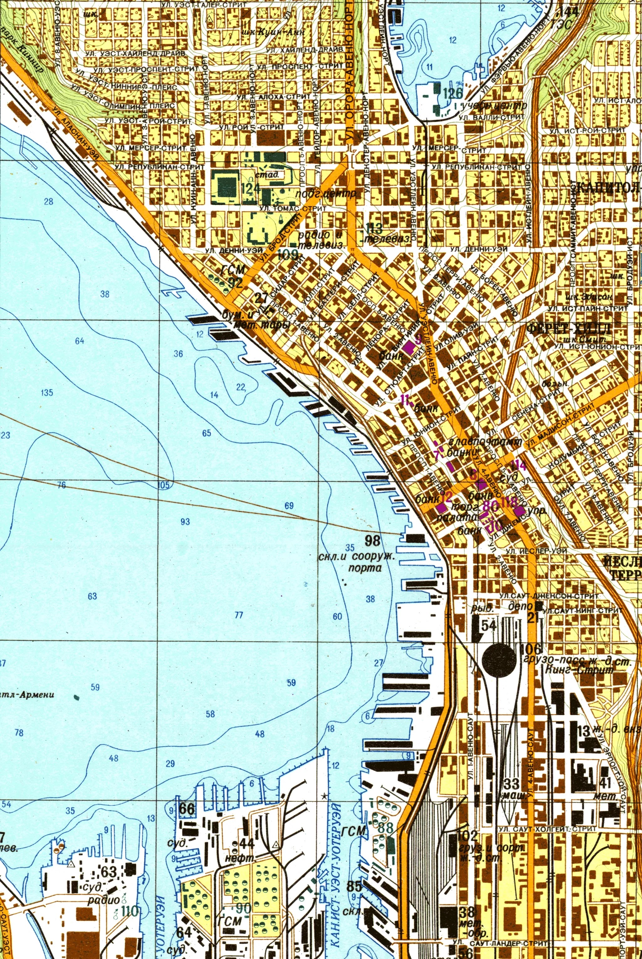
Although I was active in Naval Intelligence at that same point in time I was not aware of a significant project being maintained by The Miliary Topographic Directorate of the General Staff of the Soviet Army. Obviously it was being conducted under joint auspices with the GRU (Гла́вное разве́дывательное управле́ние, translated, Glavnoye Razvedyvatelnoye Upravlenie (Organization of the Main Intelligence Administration) of the then Soviet Union. In addition I had no need-to-know so would not have been read-in to our awareness, if it existed. It included the compilation and maintenance of more than a million detailed maps of cities and places throughout the world. A series of three (detailed/annotated) maps were specifically generated of the entire Seattle area. The date of the surviving edition is 1976. With the demise of the Soviet Union in 1991, all copies of all the maps were ordered destroyed. Somehow, due to a series of circumstances (see discussion below) at least one set survived, and was acquired by the owners of a bookshop in Riga, Latvia.
Somehow the Seattle Times newspaper had discovered the existence of the maps, and published an article on 2 June 2018. With acknowledgement and gratitude a complete copy of the article follows. In addition access to the URL affords access to other information; https://www.seattletimes.com/seattle-news/the-soviets-secret-map-of-seattle-tells-a-lot-about-us/
The Soviets’ secret map of Seattle tells a lot about us
Originally published June 2, 2018 at 6:00 am Updated June 2, 2018 at 3:40 pm
1 of 3 | Aivars Beldavs, one of the owners of the Jana Seta bookshop in Riga, Latvia, holds a paper copy of the Soviet map of Seattle. The Soviets had Seattle in three different maps, showing North, Central and South Seattle.
During the Cold War years, the Soviets ran a secret, massive program that produced a million maps of cities and places around the world. They were remarkably accurate and contained information not found on local maps — like the “explosive devices” factory in Ballard.
Erik Lacitis
Seattle Times staff reporter
This 1976 map of Seattle is not the kind you would have bought at a gas station.
No, this is a secret map put together by the Military Topographic Directorate of the General Staff of the Soviet Army. The Union of Soviet Socialist Republics (U.S.S.R.) was fond of terms like “directorate.”
Remember, in 1976, we’re still in the Cold War. It’s still the era of the “The Spy Who Came in from the Cold” and “From Russia with Love.”
Stories in the news recently are reminders of those days. We close their Russian Consulate in Seattle, citing the risk of spying. The Russians retaliate by booting out 60 American diplomats.
This map was part of a massive Cold War effort by the Soviets. Over five decades — beginning with World War II until the Soviet Union collapsed in 1991 — it produced more than a million detailed maps of cities and places around the world.
That’s the conclusion of John Davies and Alexander Kent, two British map experts. They put together 350 extracts from the maps in a 2017 book, “The Red Atlas: How the Soviet Union Secretly Mapped the World.”
Thousands of hours of manpower would have been spent on the maps.
“They must have been funded to a phenomenal degree,” Davies said in a phone interview from London.
You could call the secret 1976 map “the Soviet of Seattle,” a not-so-joking reference to the “Soviet of Washington” title reflecting this state’s (meaning Seattle’s) lefty politics as distinguished from the rest of the United States.
Besides the Seattle map extract, in the British researchers’ trove are ones of San Francisco, Los Angeles, New York, Paris, London and other cities.
The Seattle map marks one spot, No. 29, on the shores of Salmon Bay in Ballard, as “Explosion mechanisms and radio electronic devices.” An accompanying text says there is a factory there that produces “explosive devices for nuclear arms.”
What?
No. 29 is placed where 24th Avenue Northwest dead-ends at the bay, now the location of the Stimson Marina.
What did the Soviets know?
Tom Bayley, president of C.D. Stimson, has a guess.
“The Honeywell marine division pretty much occupied that whole property back in the day,” he says. “Who knows what they were building?”
A May 4, 1983, Seattle Times story about Honeywell Marine Systems Division moving from Ballard to the Mukilteo area says the company is a prime contractor for the U.S. Navy’s lightweight torpedoes, working on homing systems. The work was important enough that the facility had “to maintain security,” the story says.
(Author’s note: At that time Honeywell MSD manufactured the Torpedo, Mk46 Mod0. In addition to delivery from surface ship, aircraft, or helicopter, it was the payload of the CAPTOR (Encapsulated Torpedo) Mk60 mine. The author personally worked on tactical deployment analyses for CAPTOR.)
 |
The author standing by a CAPTOR Mk60
mine at U.S. Naval Undersea Museum, Keyport, WA |
 |
| Another view of the CAPTOR Mk60 mine |
Then there is the astonishing No. 26 on the Bellevue portion of the map, bounded by Bellevue Way Northeast to the west, Northeast Sixth Street to the north, 108th Avenue Northeast to the east, and Northeast Fourth Street to the south.
It’s abbreviated as “atom,” most likely an adjective, which, depending on the noun it went with, could stand for factory, lab or plant, explains Professor Galya Diment, a native Russian speaker with the University of Washington’s Slavic Languages & Literatures department.
She translated portions of the “spravka,” text accompanying the map. It says No. 26 is a “nuclear factory which produces nuclear fuel.”
Wait a minute.
Right smack in Bellevue?
Not according to city of Bellevue records. Spokeswoman Lenka Wright responds, “Planning and Community Development staff were unable to discover anything in the records available … that suggest these sites by the 1970s were anything but property owned by Puget Western, the real estate arm of Puget Power (now known as Puget Sound Energy)
(After this story was posted, reader Ed McDonald wrote that he used to work in sales for a high-tech company in the 1970s. “If I recall correctly, Exxon Nuclear had operations at Hanford, with offices in Bellevue where your article mentions . . . I called on them in both cities. I think the Soviet map had it nailed.”
A relatively current domestically produced aerial photograph of the exact same area for direct comparison.
(An article in The New York Times from March 14, 1976, states, “Exxon Nuclear, located in Bellevue, Wash., is attempting to become this nation’s first commercial supplier of a complete range of nuclear fuel products and services necessary to operate atomic reactor.”)
Aided by spy satellites, and picnics
Davies says the Soviet mapmakers did make some mistakes — misnamed roads, putting in nonexisting subway sections.
But he says they were also remarkably accurate, as was the case with pretty much everything on the Seattle map.
Davies says he’s been contacted by individuals involved in military operations in Afghanistan. In some cases, the vastly more comprehensive Soviet maps were used by the U.S. in its 2001 invasion.
For the overall mapping project, Davies says, the Soviet researchers “must have acquired all kinds of documentation — street directories, trade documentation.” They used U.S. Geological Survey maps but then added their own information. For Seattle, water depths for Elliott Bay were not shown on USGS mapping but they were on the Soviet map. Somehow, the Soviets determined the water depths — and they were also different from those on NOAA charts.
By 1962, the Soviets were using imagery from their Zenit spy satellites. The Soviet maps then could place new roads and housing developments that were yet to be included in local maps.
The TV series “The Americans,” about KGB officers posing as an American married couple, raises the possibility that the Soviets had spies getting information for the maps.
Yes, it happened, says Davies.
The online publication Pravda Report quotes a retired Swedish secret-police chief as saying that Soviet agents would tour Sweden to check on such map items as the load capacity of bridges and the distance between trees.
The Soviets arranged “picnics in the places of strategic interest, they would be very friendly and sociable to the local population,” says the story.
Unfortunately for one Soviet spy, his conversation with a local about specific buried cables was overheard by a Swedish spy who happened to be on the beach, too, says the story.
For Seattle, plenty was compiled, by whatever means.
There were 134 “objects of interest” listed, including 52 “factories, industrial plants, commercial premises,” with their products or purpose.
No. 123 was labeled “The Center for Space Exploration” in Kent. It’s Boeing 18-61 Building, used primarily for Department of Defense projects.
No. 51 in Redmond was identified as “the rocket factory and the science research center develop and produce engines for rockets.” That’s Aerojet Rocketdyne, which calls itself “an innovative company delivering solutions that create value for its customers in the aerospace and defense markets.”
The map doesn’t just list objects that would be construed as of military use.
No. 9 is the “People’s National Bank of Washington” in downtown Seattle.
No. 113 is “TV Station KTNT,” now KSTW.
No. 12 is simply “Paper and metal containers.”
No. 7 is the “Main Post Office.”
Then there is No. 79, offices for the Republican Party here. In Soviet parlance, it is “Department of the Central Committee of the Republican Party.” They don’t bother to list the offices for the local Democrats.
Was the purpose for the maps to prepare for a military invasion?
The maps “don’t have bombing targets,” says Davies. “In a nuclear war, what’s the point of mapping everything if you’re going to bomb it?
“The only possible underlying assumption is that they’d need (the maps) when running the city.”
The Soviets believed that capitalism would collapse, he says, and communism would be “the only world order.” The maps would help them manage that conversion.
Maybe, says Jack Barsky, 68, who was born in East Germany and from 1978 to 1988 was an agent in the U.S. for the KGB.
He now lives in the Atlanta area, has been a guest on numerous TV news shows and takes his story around the country.
Barsky says he had never known about the secret maps, although he wishes the KGB had given him some.
“My personal experience is that the KGB knew squat about Chicago in 1978 (where he first landed), or else they would have warned me of a place named the South Side,” he says.
Works of art, found by chance
Davies and his writing partner found the maps by chance.
Davies, a retired IT consultant, was working in Riga, Latvia, the former Soviet republic, in the early 2000s when he stopped by Jana Seta, a bookshop for maps.
One of the men who had started the shop, Avers Zvirbulis, had earlier come across the secret maps.
As the Soviet Union collapsed, a couple of Russian officers were told to destroy more than 6,000 tons of maps stored in Latvia.
But deals were made.
Zvirbulis negotiated to buy 100 tons of the maps, of which only two to three tons survived after kids vandalized and set fire to them, says Davies.
That’s still a lot of maps, and “The Red Atlas” authors printed 350 extracts in a painstakingly designed book.
The maps are in full color with Cyrillic wording and exquisite details — truly works of art.
On the book’s website, Davies says the writers plan to sell prints of the maps soon. For Seattle, there are maps for the north, central and south end. Each of these maps are accessible by clicking on the respective direction.
“Of course, in a world of smartphones with GPS and driving apps with voices that tell us which roads to take, and which warn us where there is a traffic jam or a speed camera, paper maps may seem an anachronism,” says Davies.
“But their historical significance cannot be denied. And neither can their beauty.”